GAF CONTINUES TO PROVIDE OCEAN COLOUR DATA TO ESA OPERATIONALLY
(firmenpresse) - (Mynewsdesk) GAF AG, the exclusive supplier in Europe of optical Indian Remote Sensing data from several missions, continues the operational provision of ocean colour data from the Ocean Colour Monitor aboard the Indian Oceansat-2 in near real time to ESA to further promote scientific research and applications.
ESA and GAF agreed the continuation of the data acquisition from the Ocean Colour Monitor (OCM) aboard the Oceansat-2 Indian remote sensing (IRS) satellite until 31?Mar?2019. Part of the agreement is also an option to extend the operations up to 31?Mar?2020.
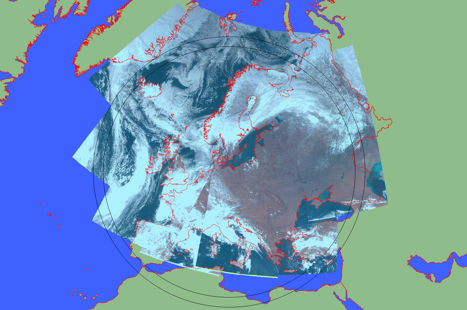
Since the start of the operational acquisitions on 1st January 2016, OCM data from all the satellite passes within the five degree visibility cone of the Neustrelitz ground station have been acquired, processed to create system corrected image products and geo-physical parameter products, and delivered to ESA in near real time (NRT) to subsequently further promote scientific research and applications. Thanks to the wide swath of the OCM, Europe and the surrounding waters are covered every two days.
After registration, the data can be accessed free of charge through ESA?s Third Party Missions dissemination service. See also ESA?s Earth Online.
GAF?s sub-contractor, the German Aerospace Agency (DLR), provides GAF with the satellite data reception service at its ground station in Neustrelitz.
The Oceansat-2 activities in Neustrelitz are funded by and carried out under the Earthnet programme and its Third Party Mission activities of the European Space Agency.
The views expressed herein can in no way be taken to reflect the official opinion of the European Space Agency.
About ESA / ESRIN:www.esa.int/About_Us/ESRIN
ESRIN, the ESA Centre for Earth Observation, is one of the five ESA specialised centres situated in Europe. Located in Frascati, a small town 20 km south of Rome in Italy, ESRIN was established in 1966 and first began acquiring data from environmental satellites in the 1970s. Since 2004, ESRIN has been the headquarters for ESAs Earth observation activities.
In addition to providing users with data from its own Earth observation satellites, ESA has for many years provided users with access to a number of non-ESA EO missions ? so called Third Party Missions (TPM). ESA?s TPM scheme has operated for more than 30 years, providing EO data to users in Europe and around the world, and currently includes over 40 instruments on more than 35 missions.
About DLR:www.dlr.de/eoc/
The German Remote Sensing Data Center (DFD) is an institute of the German Aerospace Center (DLR). Together with the centre?s Remote Sensing Technology Institute (IMF), it comprises DLR?s Earth Observation Center (EOC), which coordinates DLR?s activities relating to Earth observation data from satellites and aircraft. DFD focuses on the reception, archiving, distribution and utilisation of data.
In addition to applied research, DFD has expertise in the development and operation of satellite ground systems.
Diese Pressemitteilung wurde via Mynewsdesk versendet. Weitere Informationen finden Sie im Aigner Marketing & Communications
Shortlink zu dieser Pressemitteilung:
http://shortpr.com/debyx3
Permanentlink zu dieser Pressemitteilung:
http://www.themenportal.de/energie/gaf-continues-to-provide-ocean-colour-data-to-esa-operationally-12014Weitere Infos zu dieser Pressemeldung:
Themen in dieser Pressemitteilung:
Unternehmensinformation / Kurzprofil:
About GAF AG: http://www.gaf.de
GAF AG is an e-GEOS (Telespazio/ASI) company located in Munich and Neustrelitz, Germany. It is a leading geo-information company with an international reputation as a skilled provider of data, products and services in the fields of geo-information, spatial IT and consulting for private and public clients. As a result of a merger with its former subsidiary Euromap GmbH, GAF has become the exclusive supplier in Europe of optical Indian Remote Sensing data from several missions. The companys archives contain systematic coverage of Europe and northern Africa from 1996 and onwards, and include satellite raw data from the high and medium resolution IRS missions IRS?1C, IRS-1D, Resourcesat-1, Resourcesat-2 and Cartosat-1. GAF is also specialised in the production of orthoimage mosaics and digital elevation models from various high and very-high resolution satellite missions.
For more information, please contact:
GAF AG Daniela Miller Arnulfstr. 199
80634 Munich
Tel:+49 89 1215 28-0
info(at)gaf.de
German Aerospace Center German Remote Sensing Data Center Department: National Ground Segment Tel: +49 3981 480 111
Holger.Maass(at)dlr.de
Aigner Marketing & Communications
Birgit Aigner
Rumfordstraße 29
80469 München
info(at)aigner-marketing.de
089 543 44 065
http://shortpr.com/debyx3


Datum: 16.04.2018 - 14:05 Uhr
Sprache: Deutsch
News-ID 1600745
Anzahl Zeichen: 4582
Kontakt-Informationen:
Ansprechpartner: Birgit Aigner
Stadt:
München
Telefon: 089 543 44 065
Kategorie:
Energie & Umwelt
Diese Pressemitteilung wurde bisher 407 mal aufgerufen.
Die Pressemitteilung mit dem Titel:
"GAF CONTINUES TO PROVIDE OCEAN COLOUR DATA TO ESA OPERATIONALLY"
steht unter der journalistisch-redaktionellen Verantwortung von
Aigner Marketing& Communications (Nachricht senden)
Beachten Sie bitte die weiteren Informationen zum Haftungsauschluß (gemäß TMG - TeleMedianGesetz) und dem Datenschutz (gemäß der DSGVO).
(Mynewsdesk) ROBUSTE TABLET-LÖSUNGEN VON GETAC UNTERSTÜTZEN DIE FORTSCHREITENDE DIGITALISIERUNG IN MIT RISIKEN BEHAFTETEN INDUSTRIEZWEIGEN Düsseldorf, 27. September 2018? Getac, ein Vorreiter auf dem Gebiet der robusten mobilen Computerlösungen für ein breites Spektrum unterschiedlicher Br
GETAC PRÄSENTIERT VOLLROBUSTES K120 TABLET FÜR UNTERNEHMEN IM BEREICH DER ÖFFENTLICHEN SICHERHEIT ...
(Mynewsdesk) INNOVATIVE TECHNOLOGIEN ZUGESCHNITTEN AUF DIE TÄGLICHEN ANFORDERUNGEN VON SICHERHEITSPERSONAL Mit dem neuen K120 bringt Getac heute ein vollrobustes Tablet auf den Markt, welches darauf ausgelegt ist, Sicherheitspersonal weltweit bei der Bewältigung seiner täglichen Herausforder
LEICA GEOSYSTEMS SETZT FÜR SEINE ZENO GGO4 PLUS LÖSUNG AUF VOLLROBUSTES ZX70 TABLET VON GETAC ...
(Mynewsdesk) Zusammen mit der mobilen Software Zeno und der Smartantenne GG04 von Leica liefert das Getac ZX70 Tablet hochgenaue GIS-Daten in Echtzeit ? selbst unter anspruchsvollsten Bedingungen Getac, ein führender Anbieter robuster Computerlösungen, gab heute bekannt, dass Leica Geosystems da
Weitere Mitteilungen von Aigner Marketing& Communications
agriKomp: Leistung mit Garantie ...
Ab sofort versieht die agriKomp ihr erfolgreiches Blockheizkraftwerk BGA136 mit einer Herstellergarantie von 2 Jahren. Sie gilt für beide Leistungsklassen, nämlich 150 ? 195kWel sowie 200 ? 250 kWel. Mit dieser Maßnahme unterstreicht das Unternehmen die zuverlässigen Alltagseigenschaften des am
Verlässliche Erneuerbare Energien aus dem Untergrund ...
Nachdem sich die bisher durchgeführten DBI-Fachforen GEO-Energie an einer positiven Resonanz der Teilnehmer erfreuen konnten, findet nun vom 15. bis 16. Mai 2018 die fünfte Auflage dieses Fachforums in Berlin statt. Der fachliche Schwerpunkt am ersten Veranstaltungstag liegt in diesem Jahr auf der
Hannover Messe 2018: ENTRADE AG stellt leistungsstarkes Klein-Kraftwerk betrieben mit biogenen Reststoffen vor ...
Hohe Anlagenflexibilität: Modulare Kraftwerke von 25 kW bis zu 5 MW elektrischer Leistung Die ENTRADE Energiesysteme AG stellt auf der diesjährigen Hannover Messe ein weiteres Modell des selbst entwickelten Kraftwerks auf Basis biogener Reststoffe vor. Aktuell stehen zwei Varianten mit eine
FYI Resources: Neues Bohrprogramm soll wichtige Erkenntnisse bringen ...
Die australische FYI Resources (WKN ASX FYI / FRAU SDL) plant, hochreines Aluminiumoxid (4N oder HPA) für den schnell wachsenden LED-, Elektrofahrzeug-, Smartphone- und TV-Bildschirm-Markt zu produzieren. Die Basis dafür ist das Cadoux-Projekt des Unternehmens in Westaustralien mit seinem qualitat