New features for Leica mojoMINI and Leica mojo3D are now available
Leica Geosystems today released additional features for its guidance systems Leica mojoMINI and Leica mojo3D to further enhance product usability and compatibility
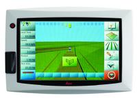
(PresseBox) - The touch screen of the Leica mojoMINI has undertaken several modifications. It offers now two lightbar modes: the traditional cross track only lightbar and the Leica smart lightbar. Furthermore farmers are able to choose the use of WAAS and EGNOS satellites or to deactivate them, if desired.
The added support for kml files gives users of the Leica mojoMINI the ability to export data of the most recent work for viewing in Google EarthTM or import into a Leica mojo3D.
Now just using the Leica mojo3D and the Leica twist allow steering of all Leica SteerDirect kits which are supported by the Leica mojoXact. To enable these extra steering options a Leica mojo3D SteerDirect kit is required. More updates to the Leica SteerDirect hydraulic solution proceed with two extra kits:
- Claas Lexion Hose Kit (Article Nr. 794531)
- Buhler 2xxx 4WD Hose Kit (Article Nr. 794540)
Like the Leica mojoMINI, the Leica mojo3D now offers the cross track only lightbar as well as the Leica smart lightbar. To further increase the compatibility of the guidance display, the support for kml and shape files has been introduced. This makes it easy to import and export field data and vehicle setups to another Leica mojo3D or different applications.
"We are pleased to introduce more open formats to further ensure the cross compatibility of our products" says Global R&D Manager Peter Roberts. "The positive market response we receive because we support open formats, like open correction formats, open data formats and open steering protocols extensively, reflects the need for flexible and versatile solutions."
Additional releases are planned for midyear and include an online service to monitor farm equipment as well as a new base station.
For more information about Leica Geosystems agriculture products visit www.AgGuidance.com
Google Earth is a trademark of Google Inc.
Whether looking to reduce input costs and increase productivity through more efficient application, or save on time and operator fatigue by lowering the number of passes in the field, Leica Geosystems provides farmers with a suite of simple, reliable and affordable agricultural guidance and precision farming tools.
Leica Geosystems' Ag Guidance solutions combine state-of-the-art positioning technology with robust, compact hardware built to withstand the toughest field conditions. Compatible with a wide range of vehicles and third party equipment and modular in software design, Leica Geosystems' products are flexible and scalable to suit individual requirements.
Leica Geosystems - when it has to be right
With close to 200 years of pioneering solutions to measure the world, Leica Geosystems products and services are trusted by professionals worldwide to help them capture, analyze, and present spatial information. Leica Geosystems is best known for its broad array of products that capture accurately, model quickly, analyze easily, and visualize and present spatial information.
Those who use Leica Geosystems products every day trust them for their dependability, the value they deliver, and the superior customer support. Based in Heerbrugg, Switzerland, Leica Geosystems is a global company with tens of thousands of customers supported by more than 3'500 employees in 28 countries and hundreds of partners located in more than 120 countries around the world. Leica Geosystems is part of the Hexagon Group, Sweden.


Datum: 27.03.2012 - 10:11 Uhr
Sprache: Deutsch
News-ID 128632
Anzahl Zeichen: 3797
contact information:
Town:
Brisbane/Heerbrugg
Kategorie:
Manufacturing & Production
Diese Pressemitteilung wurde bisher 456 mal aufgerufen.
Die Pressemitteilung mit dem Titel:
"New features for Leica mojoMINI and Leica mojo3D are now available"
steht unter der journalistisch-redaktionellen Verantwortung von
Leica Geosystems Pty Ltd (Nachricht senden)
Beachten Sie bitte die weiteren Informationen zum Haftungsauschluß (gemäß TMG - TeleMedianGesetz) und dem Datenschutz (gemäß der DSGVO).