Leica Geosystems introduces new RTK upgrade option Leica mojoXact
Today Leica Geosystems announces a new high accuracy upgrade option for the Leica mojo3D guidance display, the Leica mojoXact
(PresseBox) - The new product provides RTK positioning with the Leica Geosystems patented terrain compensation and various options for a wide range of steer kits to provide greater accuracy.
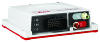
With the Leica mojoXact, Leica Geosystems introduces another user friendly product for a variety of applications to the farming community. Flexible mounting options allow users to install the product in any orientation inside the tractor cab and via a port expansion cable, it's integrated to the mojo3D within a few minutes. The robust product comes with class leading GNSS and Inertial positioning technology for continuous precision and offers additional steering solutions like SteerDirect CAN, SRK and Hydraulic for further improve accuracy.
In addition, the mojoXact supplies flexible reference data reception options including inbuilt radios for mojoRTK base station connection, external radio port, network RTK via the mojo3D screen and stand alone operations. It also uses open standards like RTCM 3.x for the system to be cross compatible with third party reference sources. "The mojoXact product takes the mojo3D product offering to another level, specifically targeted at accuracy, ease of use and flexibility of operation," says Global R&D Manager Peter Roberts.
Software for the mojoXact can be updated directly via USB Flash Drive or remotely via Virtual WrenchTM, by the use of the mojo3D. Virtual WrenchTM is the integrated web-based support and diagnostic tool to provide superior support remotely at the push of a button.
For more information about Leica Geosystems agriculture products visit www.AgGuidance.com
Whether looking to reduce input costs and increase productivity through more efficient application, or save on time and operator fatigue by lowering the number of passes in the field, Leica Geosystems provides farmers with a suite of simple, reliable and affordable agricultural guidance and precision farming tools.
Leica Geosystems' Ag Guidance solutions combine state-of-the-art positioning technology with robust, compact hardware built to withstand the toughest field conditions. Compatible with a wide range of vehicles and third party equipment and modular in software design, Leica Geosystems' products are flexible and scalable to suit individual requirements.
Leica Geosystems - when it has to be right With close to 200 years of pioneering solutions to measure the world, Leica Geosystems products and services are trusted by professionals worldwide to help them capture, analyze, and present spatial information. Leica Geosystems is best known for its broad array of products that capture accurately, model quickly, analyze easily, and visualize and present spatial information.
Those who use Leica Geosystems products every day trust them for their dependability, the value they deliver, and the superior customer support. Based in Heerbrugg, Switzerland, Leica Geosystems is a global company with tens of thousands of customers supported by more than 3'500 employees in 28 countries and hundreds of partners located in more than 120 countries around the world. Leica Geosystems is part of the Hexagon Group, Sweden.


Datum: 09.09.2011 - 09:46 Uhr
Sprache: Deutsch
News-ID 63916
Anzahl Zeichen: 3418
contact information:
Town:
Brisbane/Heerbrugg
Kategorie:
Manufacturing & Production
Diese Pressemitteilung wurde bisher 459 mal aufgerufen.
Die Pressemitteilung mit dem Titel:
"Leica Geosystems introduces new RTK upgrade option Leica mojoXact"
steht unter der journalistisch-redaktionellen Verantwortung von
Leica Geosystems Pty Ltd (Nachricht senden)
Beachten Sie bitte die weiteren Informationen zum Haftungsauschluß (gemäß TMG - TeleMedianGesetz) und dem Datenschutz (gemäß der DSGVO).