Leica Geosystems presents new product features for the Leica mojo3D at Agritechnica
After introducing the Leica mojoXact, the new high accuracy upgrade option for the Leica mojo3D guidance display, Leica Geosystems announces a number of new features for the Leica mojo3D available in November
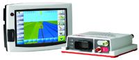
(PresseBox) - The new features include an improved look and feel of the main screen and better product usability.
Look & feel
Menu buttons were reshaped to give them a more modern look and while not in use, they now fade and become transparent to allow an enhanced view of the full display.
Usability
To increase the flexibility and usability of the Leica mojo3D, users are able to save and recall vehicle setups through the advanced vehicle setup wizard. The re-callable setups are valid for vehicles, implements and sections.
Upgraded guidance options offer users to replay any saved guidance pattern and to activate steering in reverse. The reverse guidance will be available for the hydraulic steer kit with focus on row crop tractors.
Additional changes were made to the user interface to meet Asian OEM and market demands.
"More features are planned for beginning of 2012," says Peter Roberts, Global R&D Manager. "We are pushing the use of open data standards further to ensure a cross capability, which gives farmers great flexibility and more options."
Meet us at Agritechnica in hall 16 at stand B16.
For more information about Leica Geosystems agriculture products visit www.AgGuidance.com
Whether looking to reduce input costs and increase productivity through more efficient application, or save on time and operator fatigue by lowering the number of passes in the field, Leica Geosystems provides farmers with a suite of simple, reliable and affordable agricultural guidance and precision farming tools.
Leica Geosystems' Ag Guidance solutions combine state-of-the-art positioning technology with robust, compact hardware built to withstand the toughest field conditions. Compatible with a wide range of vehicles and third party equipment and modular in software design, Leica Geosystems' products are flexible and scalable to suit individual requirements.
Leica Geosystems - when it has to be right
With close to 200 years of pioneering solutions to measure the world, Leica Geosystems products and services are trusted by professionals worldwide to help them capture, analyze, and present spatial information. Leica Geosystems is best known for its broad array of products that capture accurately, model quickly, analyze easily, and visualize and present spatial information.
Those who use Leica Geosystems products every day trust them for their dependability, the value they deliver, and the superior customer support. Based in Heerbrugg, Switzerland, Leica Geosystems is a global company with tens of thousands of customers supported by more than 3'500 employees in 28 countries and hundreds of partners located in more than 120 countries around the world. Leica Geosystems is part of the Hexagon Group, Sweden.


Datum: 04.10.2011 - 10:05 Uhr
Sprache: Deutsch
News-ID 72152
Anzahl Zeichen: 3165
contact information:
Town:
Brisbane/Heerbrugg
Kategorie:
Manufacturing & Production
Diese Pressemitteilung wurde bisher 336 mal aufgerufen.
Die Pressemitteilung mit dem Titel:
"Leica Geosystems presents new product features for the Leica mojo3D at Agritechnica"
steht unter der journalistisch-redaktionellen Verantwortung von
Leica Geosystems Pty Ltd (Nachricht senden)
Beachten Sie bitte die weiteren Informationen zum Haftungsauschluß (gemäß TMG - TeleMedianGesetz) und dem Datenschutz (gemäß der DSGVO).